Development and Application of a Multi-scale Framework for Evaluating Floodplain Restoration Suitability Based on HEC-RAS
-
摘要:目的
在城市化进程和极端气候变化的影响下,河流生态系统面临着生境退化和洪水风险。恢复河漫滩作为一种基于自然的解决方案,可提供防洪、生态及景观游憩等多重效益。因此,如何选择优先恢复的河漫滩以平衡流域的生态和社会效益,成为当前流域管理的核心科学问题。
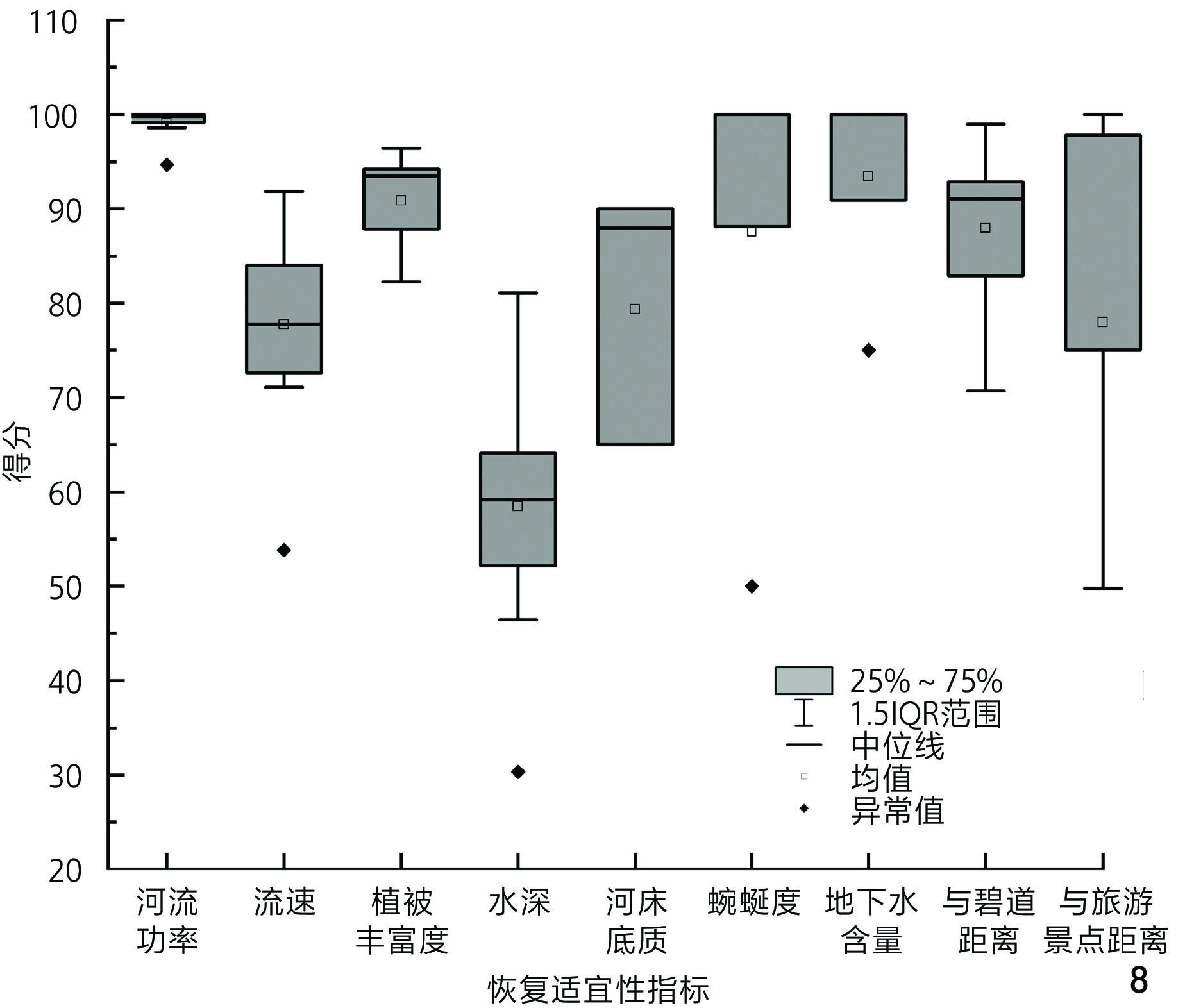
方法整合高程、土地利用、植被以及土壤等多源数据,基于地理信息系统和HEC-RAS水动力模型,提出了一套系统的河漫滩恢复适宜性评估框架,可识别各尺度上关键的水文、生态及社会经济等参数,并采用熵权法计算漫滩恢复适宜性指数。以广州流溪河中下游流域为案例,筛选高恢复适宜性的漫滩区域,并通过水动力模型验证恢复效益。
结果流溪河中下游地区漫滩恢复适宜性较高,共筛选出9个适宜恢复的区域,这些区域多位于平坦的河岸带林地和水源补给充足的区域。单个漫滩恢复后显著增强了河流的水文调节功能,洪峰流量降低了7.7%,流量过程更平稳,同时在小规模洪水作用下适宜栖息地面积增加了56.52 hm2。
结论所提出的评估框架有效识别了适宜恢复的潜在河漫滩,为科学优化河漫滩恢复选址提供了量化依据。恢复后预期可提升洪水防御和生态功能,同时兼顾社会游憩需求,为流域管理与漫滩恢复策略的制定提供了科学支持。
Abstract:ObjectiveRiver ecosystems are increasingly threatened by habitat degradation and heightened flood risks due to rapid urbanization and the intensification of extreme climate events. Restoring river floodplains, as a nature-based solution (NBS), offers a promising approach to address these challenges by providing multiple benefits, including flood control, ecological restoration, and recreational opportunities. However, identifying floodplains with high restoration suitability remains a critical scientific challenge in basin management. This research aims to develop a comprehensive framework for evaluating the suitability of river floodplains restoration, with the goal of maximizing social and ecological benefits at the basin scale. By focusing on the integration of hydrological, ecological, and socio-economic factors, this research seeks to provide a scientifically robust method for prioritizing floodplain restoration efforts.
MethodsThis research proposes a multi-dimensional floodplain restoration suitability evaluation framework, integrating Geographic Information Systems (GIS) and the HEC-RAS (Hydrologic Engineering Center’s River Analysis System) hydrodynamic model. The framework incorporates multi-source data, including digital elevation models (DEM), land use classifications, vegetation indices (NDVI), soil types, and socio-economic factors, to evaluate the restoration potential of floodplains. This research uses a multi-level hierarchical screening method to select indicators at three scales: basin, sub-basin and site. Through multi-scale and multi-dimensional synergistic evaluation, the research avoids not being able to conduct global analysis due to insufficient data, and also prevents ignoring the overall restoration effect by limiting to the local area. Key indicators such as hydrological conditions, ecological habitats, water quality, vegetation cover, and socio-economic factors are identified and quantified. The entropy weight method is employed to calculate the restoration suitability index, ensuring an objective weighting of each indicator. Finally, region-specific socio-economic factors are incorporated into the evaluation system for the final selection of restorable floodplains. Hydrodynamic simulations are conducted using HEC-RAS to model baseline and post-restoration scenarios. These simulations help evaluate changes in flood behavior and habitat conditions under various flow events. A case study is conducted in the middle and lower reaches of the Liuxi River Basin in Guangzhou, China, to validate the framework. The research area is selected due to its susceptibility to frequent flooding, rich biodiversity, and strategic importance in regional greenway planning.
ResultsThe results indicate that the middle and lower reaches of the Liuxi River Basin exhibit high floodplain restoration suitability. Nine floodplains are identified as highly suitable for restoration, located predominantly in low-slope riparian zones with minimal human development pressure. The post-restoration simulations demonstrate significant improvements in hydrological regulation, with a 7.7% reduction in flood peak flow, and smoother flow change curves. Additionally, the restoration efforts have led to a substantial increase in suitable habitats for indicator species (e.g., Spinibarbus hollandi, a local fish species), with an expansion of 56.52 hm2 under one-year flood conditions. The research also highlights the importance of socio-economic factors, such as proximity to greenways and tourist attractions, for determining the feasibility and sustainability of restoration projects. The integration of these factors ensure that the selected floodplains not only provide ecological benefits but also align with local development goals.
ConclusionThis research presents a comprehensive framework for evaluating floodplain restoration suitability that integrates hydrological modeling, ecological evaluation, and socio-economic analysis. The case study in the Liuxi River Basin demonstrates that the restored floodplains can significantly enhance flood defense capabilities and ecological functions, while also supporting recreational and socio-economic needs at multiple spatial scales. The integration of HEC-RAS simulations with GIS-based spatial data enables precise identification of high-priority areas, while the entropy weight method ensures that indicator weighting remains data-driven and objective. The framework not only enhances the scientific basis for restoration decision-making but also narrows the gap between ecological science and land-use planning. Importantly, it emphasizes the need to balance ecological objectives with socio-economic considerations, especially in densely populated and ecologically sensitive regions. As such, the methodology developed in this research may offer valuable insights for practitioners and policymakers seeking to implement nature-based solutions for river basin management. The framework is adaptable to other river systems facing similar challenges, and contributes to the broader discourse on sustainable urban water management, climate adaptation, and ecosystem resilience. Ultimately, the research underscores that successful floodplain restoration requires a holistic, interdisciplinary approach rooted in both science and local context.
-
图 9 HEC-RAS一维非恒定流验证恢复漫滩后的局部防洪效益 9-1 无堤坝情况下一年一遇洪水的模拟淹没范围 9-2 a-a′剖面的洪水波变形 9-3 a-a′剖面
Figure 9. Verification of local flood control benefits obtained after floodplain restoration based on one-dimensional non-constant flow of HEC-RAS 9-1 Simulated inundation extent of a one-year flood in the absence of dam 9-2 Flood wave deformation in the a-a’ section 9-3 a-a’ section
图 10 不同规模洪水下恢复漫滩后的生态效益 10-1 指示物种适宜的水深区域(一年一遇洪水) 10-2 指示物种适宜的流速区域(一年一遇洪水) 10-3 增加的适宜栖息地区域
Figure 10. Ecological benefits obtained after floodplain restoration under different scales of floods 10-1 Area of water depth suitable for indicator species (one-year flood) 10-2 Area of water velocity suitable for indicator species (one-year flood) 10-3 Increased areas of suitable habitat
表 1 指示物种的适宜生长环境参数
Table 1 Parameters of growing environments suitable for indicator species
环境参数 参数范围 适宜性等级 流速/m·s−1 0~<0.2 适宜 0.2~<0.6 非常适宜 0.6~<1.2 适宜 1.2~1.6 不适宜 >1.6 非常不适宜 水深/m 0~<1 适宜 1~<3 非常适宜 3~<4 适宜 4~6 不适宜 >6 非常不适宜 表 2 河漫滩生态恢复适宜性评估框架
Table 2 Framework for evaluating the ecological restoration suitability of floodplain
一级指标 二级指标 指标得分范围 适宜性得分 权重 指标尺度 一级指标 二级指标 指标得分范围 适宜性得分 权重 指标尺度 河流水文 被一年一遇洪水淹没a 是 100 0.032 7 流域 河床地貌 河流功率/W·m−2 0.0~<16.0 100 0.130 1 流域 否 0 16.0~<80.1 75 地下水埋深/m 2.99 ~<3.51 100 0.087 4 流域 80.1~<235.2 50 3.51~<3.80 75 235.2~556.0 25 3.80~<4.15 50 >556.0 0 4.15~<4.61 25 河床比降/‰ 0.000~<0.593 100 0.058 1 子流域 4.61~5.28 0 0.593~<1.780 75 流速b/m·s−1 0.00 ~<0.36 75 0.117 6 流域 1.780~<21.360 50 0.36~<0.84 100 21.360~<79.500 25 0.84~<1.47 50 79.500~151.300 0 1.47~2.40 25 河床底质b 水稻土 100 0.101 5 流域 >2.40 0 赤红壤 50 水深b/m 0.0~<1.5 50 0.103 8 流域 红壤 75 1.5~<2.5 100 黄壤 50 2.5~<5.0 75 河流连通度 蜿蜒度b 0.0~<0.8 75 0.096 5 子流域 5.0~10.0 50 0.8~<1.4 100 >10.0 25 1.4~<9.2 50 河流水质 耕地占比/% 1.0~<6.8 100 0.026 5 子流域 9.2~<52.0 25 6.8~<17.6 75 52.0~166.2 0 17.6~<30.3 50 与湿地距离/m 0~<1 177 100 0.001 1 场地 30.3~43.6 25 1 177~<2 171 75 >43.6 0 2 171~<3 270 50 地表水质量a 一类水 100 0.032 2 子流域 3 270~4 553 25 二类水 0 >4 553 0 与工厂距离/m 0~<1 966 0 0.0573 场地 与拦河坝距离/m 0~<1 267 0 0.050 7 场地 1 966~<3 612 25 1 267~<2 535 25 3 612~<5 458 50 2 535~<3 803 50 5 458~<7 585 75 3 803~5 071 75 7 585~10 234 100 >5 071 100 河岸带植被 NDVI <0.00 0 0.104 4 流域 0.00~<0.25 25 0.25~<0.50 50 0.50~<0.75 75 0.75~1.00 100 注:a为布尔型指标,明确了有无的状态并进行赋分;b为适宜性指标,在本研究根据指示物种最适宜生存的环境进行赋分;其他二级指标为正向指标或负向指标,根据Jenks自然断点法进行区分[23],采用五分法进行打分。 -
[1] 郭二辉,杨喜田,陈利顶.河岸带生态功能认知及河流景观偏好的调查研究[J].中国园林,2017,33(1):95-99. doi: 10.3969/j.issn.1000-6664.2017.01.019 GUO E H, YANG X T, CHEN L D. Research of Resident’s Perceptions to Ecological Functions of Riparian Buffers and Their Preferences for River Landscape[J]. Chinese Landscape Architecture, 2017, 33 (1): 95-99. doi: 10.3969/j.issn.1000-6664.2017.01.019
[2] LIU Z M, CAI Y T, WANG S W, et al. Small and Medium-Scale River Flood Controls in Highly Urbanized Areas: A Whole Region Perspective[J]. Water, 2020, 12 (1): 182. doi: 10.3390/w12010182
[3] 袁兴中,贾恩睿,刘杨靖,等.河流生命的回归:基于生物多样性提升的城市河流生态系统修复[J].风景园林,2020,27(8):29-34. YUAN X Z, JIA E R, LIU Y J, et al. Return of River Life: Restoration of Urban River Ecosystem Based on Improvement of Biodiversity[J]. Landscape Architecture, 2020, 27 (8): 29-34.
[4] CANTO-PERELLO J, MARTINEZ-LEON J, CURIEL-ESPARZA J, et al. Consensus in Prioritizing River Rehabilitation Projects Through the Integration of Social, Economic and Landscape Indicators[J]. Ecological Indicators, 2017, 72: 659-666. doi: 10.1016/j.ecolind.2016.09.004
[5] ROHDE S, HOSTMANN M, PETER A, et al. Room for Rivers: An Integrative Search Strategy for Floodplain Restoration[J]. Landscape and Urban Planning, 2006, 78 (1/2): 50-70.
[6] FUNK A, MARTÍNEZ-LÓPEZ J, BORGWARDT F, et al. Identification of Conservation and Restoration Priority Areas in the Danube River Based on the Multi-functionality of River-Floodplain Systems[J]. Science of The Total Environment, 2019, 654: 763-777. doi: 10.1016/j.scitotenv.2018.10.322
[7] GUIDA R J, SWANSON T L, REMO J W F, et al. Strategic Floodplain Reconnection for the Lower Tisza River, Hungary: Opportunities for Flood-Height Reduction and Floodplain-Wetland Reconnection[J]. Journal of Hydrology, 2015, 521: 274-285. doi: 10.1016/j.jhydrol.2014.11.080
[8] REMO J W F, CARLSON M, PINTER N. Hydraulic and Flood-Loss Modeling of Levee, Floodplain, and River Management Strategies, Middle Mississippi River, USA[J]. Natural Hazards, 2012, 61 (2): 551-575. doi: 10.1007/s11069-011-9938-x
[9] SHI L D, SYLMAN S, HULET C, et al. Integrating Social and Ecological Considerations in Floodplain Relocation and Restoration Programs[J]. Socio-Ecological Practice Research, 2023, 5 (3): 239-251. doi: 10.1007/s42532-023-00152-y
[10] WORLEY L C, UNDERWOOD K L, DIEHL R M, et al. Balancing Multiple Stakeholder Objectives for Floodplain Reconnection and Wetland Restoration[J]. Journal of Environmental Management, 2023, 326: 116648. doi: 10.1016/j.jenvman.2022.116648
[11] HABERSACK H, SCHOBER B, HAUER C. Floodplain Evaluation Matrix (FEM): An Interdisciplinary Method for Evaluating River Floodplains in the Context of Integrated Flood Risk Management[J]. Natural Hazards, 2015, 75 (1): 5-32.
[12] SCHOBER B, HAUER C, HABERSACK H. A Novel Assessment of the Role of Danube Floodplains in Flood Hazard Reduction (FEM Method)[J]. Natural Hazards, 2015, 75 (1): 33-50. doi: 10.1007/s11069-014-1306-1
[13] RANGARI V A, SRIDHAR V, UMAMAHESH N V, et al. Floodplain Mapping and Management of Urban Catchment Using HEC-RAS: A Case Study of Hyderabad City[J]. Journal of the Institution of Engineers (India): Series A, 2019, 100 (1): 49-63. doi: 10.1007/s40030-018-0345-0
[14] JAFARZADEGAN K, MERWADE V. A DEM-Based Approach for Large-Scale Floodplain Mapping in Ungauged Watersheds[J]. Journal of Hydrology, 2017, 550: 650-662. doi: 10.1016/j.jhydrol.2017.04.053
[15] LI Y L, ZHANG Q, LU J R, et al. Assessing Surface Water − Groundwater Interactions in a Complex River-Floodplain Wetland-Isolated Lake System[J]. River Research and Applications, 2019, 35 (1): 25-36. doi: 10.1002/rra.3389
[16] HU X Z, ZHANG Y Y, YANG F, et al. An Efficiency Analysis of the Low-Head Gate Dam Fishway for Freshwater Fish Ascending Liuxi River in South China[J]. Ecological Engineering, 2020, 158: 106018. doi: 10.1016/j.ecoleng.2020.106018
[17] LI X Y, ZHANG Q R, DIAO Y F, et al. Ecological Flow Considering Hydrological Season and Habitat Suitability for a Variety of Fish[J]. Ecological Modelling, 2024, 489: 110625. doi: 10.1016/j.ecolmodel.2024.110625
[18] NEDEAU E J, MERRITT R W, KAUFMAN M G. The Effect of an Industrial Effluent on an Urban Stream Benthic Community: Water Quality vs. Habitat Quality[J]. Environmental Pollution, 2003, 123 (1): 1-13. doi: 10.1016/S0269-7491(02)00363-9
[19] MAGILLIGAN F J, BURAAS E M, RENSHAW C E. The Efficacy of Stream Power and Flow Duration on Geomorphic Responses to Catastrophic Flooding[J]. Geomorphology, 2015, 228: 175-188. doi: 10.1016/j.geomorph.2014.08.016
[20] AHILAN S, GUAN M, SLEIGH A, et al. The Influence of Floodplain Restoration on Flow and Sediment Dynamics in an Urban River[J]. Journal of Flood Risk Management, 2018, 11 (S2): S986-S1001.
[21] MENON M. Assessing the Habitat Suitability of Paddy Fields for Avian Indicators Based on Hydropedological Parameters of the Wet Agricultural Soil Along the Cauvery Delta Basin, India[J]. Paddy and Water Environment, 2021, 19 (1): 11-22. doi: 10.1007/s10333-020-00816-5
[22] ZHAO J C, JI G X, TIAN Y, et al. Environmental Vulnerability Assessment for Mainland China Based on Entropy Method[J]. Ecological Indicators, 2018, 91: 410-422. doi: 10.1016/j.ecolind.2018.04.016
[23] CHEN J, YANG S T, LI H W, et al. Research on Geographical Environment Unit Division Based on the Method of Natural Breaks (Jenks)[J]. ISPRS-International Archives of the Photogrammetry, Remote Sensing and Spatial Information Sciences, 2013, XL4: 47-50.
[24] 马向明,赵嘉新,魏冀明,等.万里碧道:生态文明背景下广东河湖水系水-岸协同治理的探索与实践[J].南方建筑,2021(6):10-21. doi: 10.3969/j.issn.1000-0232.2021.06.002 MA X M, ZHAO J X, WEI J M, et al. Ecological Belt: Guangdong’s Exploration and Practice on Water-Shore Collaborative Governance of River and Lake Systems in the Context of Promoting Ecological Civilization[J]. South Architecture, 2021 (6): 10-21. doi: 10.3969/j.issn.1000-0232.2021.06.002
[25] PALT M, LE GALL M, PIFFADY J, et al. A Metric-Based Analysis on the Effects of Riparian and Catchment Landuse on Macroinvertebrates[J]. Science of The Total Environment, 2022, 816: 151590. doi: 10.1016/j.scitotenv.2021.151590
[26] FUNK A, BALDAN D, BONDAR-KUNZE E, et al. Connectivity as a Driver of River-Floodplain Functioning: A Dynamic, Graph Theoretic Approach[J]. Ecological Indicators, 2023, 154: 110877. doi: 10.1016/j.ecolind.2023.110877
[27] BROUWER R, VAN EK R. Integrated Ecological, Economic and Social Impact Assessment of Alternative Flood Control Policies in the Netherlands[J]. Ecological Economics, 2004, 50 (1/2): 1-21.
[28] 刘明欣,王世福,谢纯.瑞士图尔河再自然化的理念与措施[J].国际城市规划,2017,32(5):111-120. doi: 10.22217/upi.2015.444 LIU M X, WANG S F, XIE C. Re-naturalizing the Thur River: Theories and Measures[J]. Urban Planning International, 2017, 32 (5): 111-120. doi: 10.22217/upi.2015.444
[29] KRAUSE S, BRONSTERT A, ZEHE E. Groundwater − Surface Water Interactions in a North German Lowland Floodplain − Implications for the River Discharge Dynamics and Riparian Water Balance[J]. Journal of Hydrology, 2007, 347 (3/4): 404-417.
[30] CUESTA F, CALDERÓN-LOOR M, ROSERO P, et al. Seasonally Flooded Landscape Connectivity and Implications for Fish in the Napo Moist Forest: A High-Resolution Mapping Approach[J]. Global Ecology and Conservation, 2024, 56: e03257. doi: 10.1016/j.gecco.2024.e03257


 下载:
下载:





 微信服务号
微信服务号
 手机在线阅读
