CN 11-5366/S ISSN 1673-1530
"Landscape Architecture is more than a journal."
- Core Journal of China
- Source Journal for Chinese Scientific and Technical Papers and Citations
| Citation: |
WANG J Q, JIANG H Q, WANG M. Water Habitat Image Classification and Quality Evaluation Based on Deep Learning: A Case Study of the Pilot Zone of the Yangtze River Delta Integration Area[J]. Landscape Architecture, 2023, 30(7): 22-28.

|
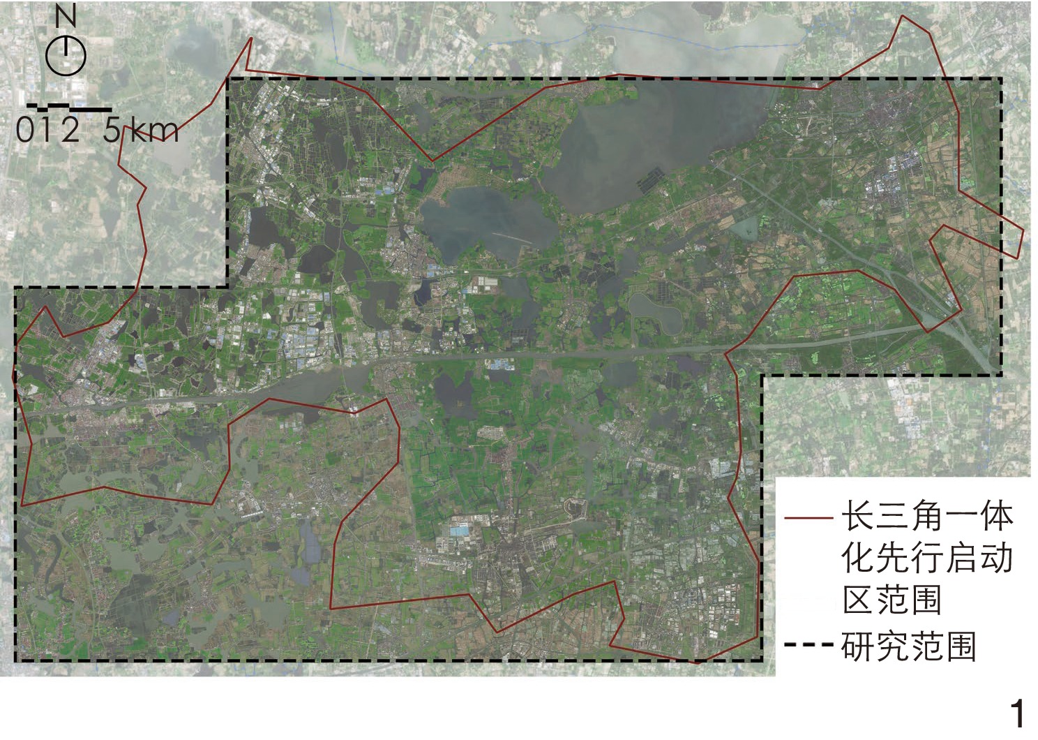
The Yangtze River Delta (“YRD”) integration area is one of the most typical water network areas in southern China, where river and canal networks are interwoven, and ponds and lakes are widely scattered. Water bodies serve as the lifeline of the water towns in southern China, and it is crucial to improve the water ecosystem services of water bodies therein. With the development of river and lake ecology restoration work, the evaluation of water habitat quality has gradually become a hot topic. Through a literature review, it is found that the shortcomings of existing research are as follows: in terms of research objective, most of existing researches in China focus on rivers in the plain river network area in northern China or the mountainous areas in southern China, while paying less attention to the water network in the Yangtze River Delta; in terms of research content, the focus is on high-precision evaluation of the entire river basin or macro, qualitative research on large-scale areas, and there is still a lack of large-scale, large-sample and refined classification evaluation research; in terms of research method, although there are relatively mature evaluation systems internationally, they are mostly based on field surveys and sampling surveys, which are time-consuming and featured by small sample size, limited evaluation range and poor data tracking, often unable to keep up with the speed of land use and cover change. For the high-density water network in the YRD integration area, existing research methods have obvious technical bottlenecks and fail to meet the practical requirements of ecological restoration planning and design. In response to the higher demand for high-quality ecological restoration and intelligent monitoring in the YRD integration area with a focus on the quality of water habitat, this research proposes that large-scale and large-batch satellite images of water habitat can be intelligently identified, classified and evaluated through the training of convolutional neural networks (CNN) involved in deep learning (DL), aiming to explore the forefront of digital technology in landscape architecture, and provide information and intelligent technical support for the integration of ecological and green development in the YRD area.
This research proposes an image classification method based on convolutional neural networks (CNN) and utilizes satellite images obtained through network channels in the YRD integration aera as a dataset (including training, testing, and validation sets) for pre-processing. The Urban River Survey (URS) is used as the evaluation index system of image classification for water habit in the YRD integration area, and the dataset is annotated for classification. The deep learning model is trained using the training set, and the accuracy of the model is tested using the testing set. The parameters are continuously adjusted, and the model is evaluated using the validation set. The trained deep learning model can quickly identify satellite images in the YRD integration area and intelligently classify and evaluate water habitat quality.
Water habitat quality can be evaluated from the three aspects of physical habitat, vegetation type and material type, and classified according to the SHQI grading evaluation standard. The results show that the water habitat quality of the YRD integration area should be improved. The number of water habitats with particularly good quality is relatively few, mainly because of high artificialization of water barges, few types of riverway habitats, relatively single vegetation type in the riparian zone, and navigable water transport. Water habitats with relatively good quality often have the following characteristics: a high proportion of natural or naturalized banks, multiple types of habitats such as shallow shoals and streams in riverways, rich vegetation in the riparian zone, various aquatic plants in riverways, few riverway revetments, and materials dominated by mainly biodegradable revetments (such as reeds and wooden stakes) or open cornerstone revetments (such as ripraps and stone cages). In the vast agricultural land, the water habitat quality is relatively poor, generally rated as “Below Average” or “Poor”. The characteristics of these areas include a single type of river habitat, few or no vegetation cover in the riparian zone, and hard revetments in artificially excavated waterways. Due to the highly engineered waterways in urban areas, villages or residential areas, the water habitat quality is mainly rated as “Poor”.
The evaluation of water habitat quality is a crucial aspect of water ecology restoration in the context of booming ecological green integration in the Yangtze River Delta. This research constructs a water habitat quality evaluation index system by selecting evaluation indicators based on image perception, and trains a deep learning model using image classification methods. The application of deep learning models can conduct long-term and large-scale quality evaluation of water habitats, improve work efficiency, expand the spatiotemporal dimension of water habitat quality evaluation, and reveal the changes in water habitat quality. By updating image data, it can track and monitor the water habitat quality in the YRD integration area, and explore the development of digital technology in the field of landscape ecology, and provide technical support for the restoration of water habitat and green development in the YRD area.
| [1] |
王云才,陈田,郭焕成.江南水乡区域景观体系特征与整体保护机制[J].长江流域资源与环境,2006,15(6):708-712. doi: 10.3969/j.issn.1004-8227.2006.06.006
WANG Y C,CHEN T,GUO H C. Mechanisms in Conservation of Regional Landscape System for Ancient Water Towns in the Southern Yangtze River Area[J]. Resources and Environment in the Yangtze Basin,2006,15 (6): 708-712. doi: 10.3969/j.issn.1004-8227.2006.06.006
|
| [2] |
中华人民共和国生态环境部生态环境监测司.河流水生态环境质量监测与评价技术指南(征求意见稿)[R/OL].[2023-02-04]. https://www.mee.gov.cn/xxgk2018/xxgk/xxgk06/202009/W020210319358527919351.pdf
Ministry of Ecology and Environment of the People’s Republic of China. Technical Guidelines for Water Eco-Environmental Quality Monitoring and Evaluating of River and Stream (Draft for Comments)[R/OL]. [2023-02-04]. https://www.mee.gov.cn/xxgk2018/xxgk/xxgk06/202009/W020210319358527919351.pdf
|
| [3] |
江卉卿,汪洁琼.基于文献计量分析的河流生境质量评价研究[J].城市建筑,2021,18(22):79-83.
JIANG H Q,WANG J Q. Review and Prospect of River Habitat Quality Assessment Based on Bibliometric Analysis[J]. Urbanism and Architecture,2021,18 (22): 79-83.
|
| [4] |
王建华,田景汉,吕宪国.挠力河流域河流生境质量评价[J].生态学报,2010,30(2):481-486.
WANG J H,TIAN J H,LÜ X G. Assessment of Stream Habitat Quality in Naoli River Watershed,China[J]. Acta Ecologica Sinica,2010,30 (2): 481-486.
|
| [5] |
刘华,蔡颖,於梦秋,等.太湖流域宜兴片河流生境质量评价[J].生态学杂志,2012,31(5):1288-1295.
LIU H,CAI Y,YU M Q,et al. Assessment of River Habitat Quality in Yixing District of Taihu Lake Basin[J]. Chinese Journal of Ecology,2012,31 (5): 1288-1295.
|
| [6] |
王强,袁兴中,刘红,等.基于河流生境调查的东河河流生境评价[J].生态学报,2014,34(6):1548-1558.
WANG Q,YUAN X Z,LIU H,et al. Stream Habitat Assessment of Dong River,China,Using River Habitat Survey Method[J]. Acta Ecologica Sinica,2014,34 (6): 1548-1558.
|
| [7] |
曾鹏,汪昱昆,刘垚燚,等.基于河段尺度的太湖流域城市河流生境评价[J].应用生态学报,2020,31(2):581-589.
ZENG P,WANG Y K,LIU Y Y,et al. A River Stretch Scale Assessment of Urban River Habitat in the Taihu Lake Basin[J]. Chinese Journal of Applied Ecology,2020,31 (2): 581-589.
|
| [8] |
周飞燕,金林鹏,董军.卷积神经网络研究综述[J].计算机学报,2017,40(6):1229-1251.
ZHOU F Y,JIN L P,DONG J. Review of Convolutional Neural Network[J]. Chinese Journal of Computers,2017,40 (6): 1229-1251.
|
| [9] |
刘伦,王辉.城市研究中的计算机视觉应用进展与展望[J].城市规划,2019,43(1):117-124.
LIU L,WANG H. Application of Computer Vision in Urban Studies: Review and Prospect[J]. City Planning Review,2019,43 (1): 117-124.
|
| [10] |
NAIK N, PHILIPOOM J, RASKAR R, et al. Streetscore-Predicting the Perceived Safety of One Million Streetscapes[C]//IEEE. 2014 IEEE Conference on Computer Vision and Pattern Recognition Workshops. Columbus: IEEE, 2014: 793-799.
|
| [11] |
SALESSES P,SCHECHTNER K,HIDALGO C A. The Collaborative Image of the City: Mapping the Inequality of Urban Perception[J]. Plos One,2013,8 (7): e68400. doi: 10.1371/journal.pone.0068400
|
| [12] |
甘欣悦,佘天唯,龙瀛.街道建成环境中的城市非正规性:基于北京老城街景图片的人工打分与机器学习相结合的识别探索[J].时代建筑,2018(1):62-68.
GAN X Y,SHE T W,LONG Y. Understanding Urban Informality in Street Built Environment Combining Manual Evaluation with Machine Learning in Processing the Beijing Old City's Street-View Images[J]. Time + Architecture,2018 (1): 62-68.
|
| [13] |
叶宇,张灵珠,颜文涛,等.街道绿化品质的人本视角测度框架:基于百度街景数据和机器学习的大规模分析[J].风景园林,2018,25(8):24-29.
YE Y,ZHANG L Z,YAN W T,et al. Measuning Street Greening Quality from Humanistic Perspective: A Large-Scale Analysis Based on Baidu Street View Images and Machine Learning Algorithms[J]. Landscape Architecture,2018,25 (8): 24-29.
|
| [14] |
胡一可,张天霖,王磊,等.景观服务视角下城市街区感知测度及空间分布特征[J].风景园林,2022,29(10):45-52. doi: 10.14085/j.fjyl.2022.10.0045.08
HU Y K,ZHANG T L,WANG L,et al. Measurement and Spatial Distribution of Perception in Urban Blocks from the Perspective of Landscape Service[J]. Landscape Architecture,2022,29 (10): 45-52. doi: 10.14085/j.fjyl.2022.10.0045.08
|
| [15] |
LIESHOUT C V,OEVEREN K V,EMMERIK T V,et al. Automated River Plastic Monitoring Using Deep Learning and Cameras[J]. Earth and Space Science,2020,7 (8): e2019EA000960.
|
| [16] |
LEE S,LEE D. Improved Prediction of Harmful Algal Blooms in Four Major South Korea’s Rivers Using Deep Learning Models[J]. International Journal of Environmental Research and Public Health,2018,15 (7): 1322. doi: 10.3390/ijerph15071322
|
| [17] |
VANDAELE R,DANCE S L,OJHA V. Deep Learning for Automated River-Level Monitoring Through River-Camera Images: An Approach Based on Water Segmentation and Transfer Learning[J]. Hydrology and Earth System Sciences,2021,25 (8): 4435-4453. doi: 10.5194/hess-25-4435-2021
|
| [18] |
SZOSZKIEWICZ K,BUFFAGNI A,DAVY-BOWKER J,et al. Occurrence and Variability of River Habitat Survey Features Across Europe and the Consequences for Data Collection and Evaluation[J]. Hydrobiologia,2006,566 (1): 267-280. doi: 10.1007/s10750-006-0090-7
|
| [19] |
BARBOUR M T, GERRITSEN J, SNYDER B D, et al. Rapid Bioassessment Protocols for Use in Streams and Wadeable Rivers: Periphyton, Benthic Invertebrates and Fish[M]. Washington, DC: U.S. Environmental Protection Agency, Office of Water, [1999].
|
| [20] |
LADSON A R,WHITE L J,DOOLAN J A,et al. Development and Testing of an Index of Stream Condition for Waterway Management in Australia[J]. Freshwater Biology,1999,41 (2): 453-468. doi: 10.1046/j.1365-2427.1999.00442.x
|
| [21] |
SHUKER L,GURNELL A M,RACO M. Some Simple Tools for Communicating the Biophysical Condition of Urban Rivers to Support Decision Making in Relation to River Restoration[J]. Urban Ecosystems,2012,15 (2): 389-408. doi: 10.1007/s11252-011-0207-2
|
| [22] |
GURNELL A,LEE M,SOUCH C. Urban Rivers: Hydrology,Geomorphology,Ecology and Opportunities for Change[J]. Geography Compass,2007,1 (5): 1118-1137. doi: 10.1111/j.1749-8198.2007.00058.x
|
| [23] |
SHUKER J L,MOGGRIDGE H L,GURNELL A M. Assessment of Hydromorphology Following Restoration Measures in Heavily Modified Rivers: Illustrating the Potential Contribution of the Urban River Survey to Water Framework Directive Investigations[J]. Area,2015,47 (4): 396-407. doi: 10.1111/area.12185
|
| [24] |
GURNELL A, SHUKER L, WHARTON G. URS Classifications and Indices[R]. London: Queen Mary University, 2015.
|
| [25] |
WANG M,HOU X,WANG F,et al. Influencing Mechanism of Ecological Aesthetic Preference on Urban River Ecological Restoration: A Case Study of Kunshan,Jiangsu Province[J]. Landscape Architecture Frontiers,2022,10 (1): 40-63.
|
| 1. |
丁金华,褚涵,杨阳. 基于电路理论的苏南水网地区绿色基础设施网络构建——以苏州南星湖片区为例. 西北林学院学报. 2025(01): 252-262 .

| |
| 2. |
戈晓宇,翟哲然,黄子玲,解圆圆,王海燕,兰雨萌,王帅清,汶宣彤. 智能算法在生态学研究多元场景中的应用进展. 生态学报. 2025(02): 1013-1047 .
| |
| 3. |
何春杉,李晓兵,梁瑞峰,李克锋. 基于景观格局指数的河流生境特征描述方法研究. 人民长江. 2024(08): 45-52 .
| |
| 4. |
史舒琳,王暠,杨锐. 人工智能推动中国风景园林专业发展的潜力及路径. 中国园林. 2024(09): 6-14 .
|

 WeChat Subscription
  WeChat Official
  Online Reading with
 You are the 5730921 visitor of this site
Website Copyright ©Beijing Landscape Architecture Journal Periodical Office Co., Ltd. 京ICP备2022031247号-2
Supported by: Beijing Renhe Information Technology Co., Ltd. 
 DownLoad: